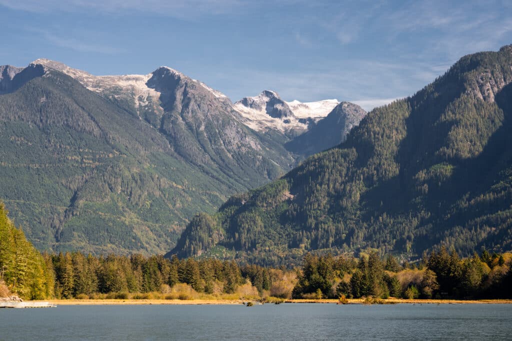
Strathcona Provincial Park is one of the premier hiking destinations in British Columbia. The park is renowned for having the the tallest mountains on Vancouver Island like the Golden Hinde, Elkhorn and Mt. Colonel Foster. While those peaks are only accessible to experienced mountaineers, there are many smaller summits that offer spectacular views of the mountains in Strathcona Park.

Read on to find out our top 5!

Bedwell Lake
- When to go- Trail is usually snow-free by late June/ early July
- Difficulty – Moderate
- Accessed By- To find the trailhead travel along Buttle Lake road until the turn to Jim Mitchell Lake Road. It is 7km until the start of the trail. It is worth noting this road is gravel and unmaintained which is best suited for vehicles with 4 wheel drive and high clearance.
Baby Bedwell Lake and Bedwell Lake are pristine lakes located at the south end of Buttle Lake. Both offer great swimming, tent platforms, and stunning views of Mount Tom Taylor and Big Interior Mountain. The hike to Baby Bedwell Lake is a 4 km hike, making it a great turnaround point for those looking to day trip, while there dive in for a refreshing dip in the crisp alpine lake.
Those looking to camp, can set up at Baby Bedwell or continue 2 km further and set up at Bedwell Lake.
The elevation gain from the parking lot to Bedwell Lake is about 500 m which makes it a moderately easy way to get great mountain views.


Mount Albert Edward
- When to go- Trail is usually snow free by August
- Difficulty – Strenuous
- Accessed by- Forbidden Plateau. To get to the trailhead head south along Highway 19, follow the signs for Mount Washington Alpine Resort and continue up Strathcona Parkway to the parking lot at Raven Lodge.
Mount Albert Edward, is Vancouver Island’s sixth highest peak, it is one of the safest mountains to summit in the park. There is a wide ridge that takes you up to the peak and the terrain is fairly untechnical, making it a favourite with locals and tourists alike.
The landscape also includes lush forest and subalpine meadows. It is best done as a two or three day hike with a base camp at the Circlet Lake backcountry campsite.
Local tip: the tent platforms at Circlet Lake tend to fill up on weekends during July and August so plan your trip for a weekday if possible.
The total distance to reach Mt. Albert Edward,is a little over 30 km with 1000 m of elevation gain. It is 10.5 km to Circlet Lake which takes 3-4 hours with a full overnight pack. Make sure you fill up your water bottles (and don’t forget to treat it) at Circlet Lake as it is the last reliable water source before the summit. The return trip from Circlet Lake to the summit is about 11 km and is where most of the elevation gain happens, estimated time for this portion is around 6 hours. From the summit of Albert Edward many of the highest mountains on Vancouver Island are visible and there are panoramic views in every direction. After you head down from the summit be sure to go for a swim in Circlet Lake.
Crest Mountain
- When to go- Trail is usually snow free by late June
- Difficulty – Strenuous
- Accessed by- Highway 28 about a hour and a half drive from Campbell River
Crest Mountain provides spectacular views of nearby Kings Peak, that is if you’re willing to tackle the 1250 m of elevation gain. The trail is well engineered with many switchbacks and it is only 5 km to the summit. Hiking times can vary from 5-8 hours.
The trail winds its way through dense forest for much of the hike and then breaks out into a subalpine meadow with a beautiful lake and breathtaking views.


Elk River Trail- Landslide Lake
- When to go- Trail is usually snow free by June
- Difficulty- Moderate
- Accessed by: Highway 28 about an hour and half from Campbell River
Landslide Lake, is a turquoise gem nestled at the base of rugged Mount Colonel Foster. In 1946 a large earthquake struck Vancouver Island and caused Mount Colonel Foster to slide, forming the remarkable slide zone for which the lake was named.
The trail follows the scenic Elk River Valley for 11 km before reaching Landslide Lake. You will travel through the forest passing waterfalls and views of the river and surrounding mountains. The Elk River Trail can be done as a long day hike or an overnight excursion.
If day hiking, leave early in the morning and allow 7-10 hours return. Campsites are located at the 6 km mark and the 9 km mark. It is important to note that camping is not allowed right at Landslide Lake, in an effort to reduce environmental impact.
Cruikshank Canyon
- When to go- Trail is usually snow free by July
- Difficulty- Moderate
- Accessed by- Forbidden Plateau. To get to the trailhead head south along Highway 19, follow the signs for Mount Washington Alpine Resort and continue up Strathcona Parkway to the parking lot at Raven Lodge.
Starting in the subalpine Paradise Meadows on Mt. Washington the hike to Cruikshank Canyon offers mountain views and stunning lakes. We recommend doing this trail as a loop which will take you past the scenic Croteau and Lady lakes making the most out of your time in the subalpine.
Round trip this hike is 20 km with about 500 m of elevation gain. There is a backcountry campsite at Kwai Lake which is located less than an hour from the Cruikshank Canyon lookout, the hike can be done as either an overnight or day hike. (*Allow 7-9 hours if you are planning on day hiking.)
The many mountains in Strathcona Park are on full display at the lookout. Try to find Castlecrag Mountain it is distinguishable by it’s rugged shape!


Before You Go
Before heading out into the park be sure to check the latest trail conditions.
These trails are a part of a delicate eco-system there are no fires allowed within the park at anytime of the year. In order to keep these places beautiful please practice leave no trace and pack out what you pack in.


How to Get There
Strathcona Park is located on central Vancouver Island, Campbell River and the Comox Valley, are the primary access points to the park.
Buttle Lake: The main access to Strathcona Park is via Highway 28, which connects with Gold River on the west coast of Vancouver Island. Follow Hwy 19 north past Courtenay to Campbell River, then follow Hwy 28 west for 48 km. Hwy 28 passes through the northern section of the park and provides access to Buttle Lake. Gas and services are not available between Campbell River and Gold River.
Forbidden Plateau: The main access route to Forbidden Plateau from Courtenay and Campbell River is via the Paradise Meadows Trailhead at Mount Washington. From Highway 19 follow signs to Mount Washington Ski Resort via exit #130 (the Strathcona Parkway) for 20 km. Turn left onto the Nordic Lodge road for 1.5 km to the Paradise Meadows parking lot.
Happy trails! Be sure to share your hiking adventures with us using #DiscoverCampbellRiver